

Last week an Isolated High Level Depression affected the entire Iberian Peninsula leaving record rainfall that caused five deaths and numerous material damages. The alleged embarrassing “error” of the AEMET in its predictions and the management of the emergency services, considered by some as “catastrophist”, with the activation of a mobile alert sent by radio broadcast, caused a media uproar. There were journalists who said that the mobile alert was an experiment in mass control, and the mayor of Madrid, José Luis Martínez-Almeida, lashed out at the AEMET demanding greater accuracy in forecasts. However, analyzing the predictions and the events that occurred, I personally believe that the actions of the AEMET and the Security and Emergency Agency 112 in Madrid were impeccable. And I would like to explain why.
The first thing is to know what a DANA is. And no, it is not a term used by ‘climatrophists’ to warn of climate change. A DANA is the acronym for Isolated High-Level Depression. In the atmosphere there are air currents, similar to ocean currents -remember how the turtles traveled in Nemo’s movie-. One of the most famous is called the Jet Stream, a highway in the troposphere where air travels at 150 to 200 kilometers per hour thanks to the temperature difference between the tropics and the poles. This current surrounds the planet from west to east. Well, a DANA is formed when this current breaks and forms an isolated circulation of the Jet Stream. In our geography they usually cause extreme phenomena, especially in autumn, when the sea is still warm – remember that this year both the Atlantic and the Mediterranean were much warmer than normal. This cold air at high altitude encounters the warm sea, giving rise to very significant atmospheric instability. September is a common month for this type of atmospheric configuration to occur. In fact, there is a Spanish popular saying that goes like this: “September either dries up the fountains or takes away the bridges”. And the latter was exactly what happened.
Dancing with probability
DANAS are a headache for meteorologists because predictive models often do not track them well, leading to many scenarios. The atmosphere is very complex and it is impossible to know where it will rain with complete accuracy. Predictive models have improved a lot compared to the 1980s, but it is also increasingly difficult to improve predictions further. Not because there is no intention to do so, but because the physics that explains these phenomena prevents it. We often hear in media and RRSS that how is it possible that meteorologists do not know what will happen in a week, but they do in 30 years, implying that climate change is an absolute hoax. Without going into too much detail, meteorology is one thing and climatology is quite another.. That the latter says that there is an increase in temperature does not mean that in the future there will not be lower temperatures than normal. In other words, Filomena -name of the storm that froze Spain with record low temperatures in 2021- does not deny the increase in temperature that Spain has experienced in the last 60 years.
Returning to the DANA, there are several predictive models. The most important are the ECMWF (the European model) and the GFS (the American model). On August 24, more than a week before the events took place, the GFS already showed a DANA to the southwest of the peninsula for the beginning of September. However, these maps are always probabilistic and every minute that passes new variables are incorporated that had not been taken into account before. A long-term model has to be taken with tongs, because the probability that a scenario will be fulfilled ten days ahead -and even more so when talking about a DANA- is very small.
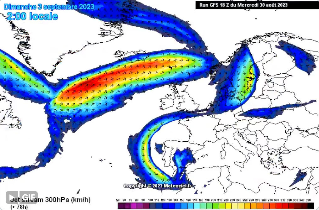
On the 25th, the ECMWF model also showed a DANA, but, even when the two major models coincide, the probability is still very low. In fact, on the 26th, the models showed a very different configuration. On the 27th, they went back in action and the ECMWF showed a perfect DANA -see the image-. The following days, 28th and 29th, the models consolidated the possibility of this scenario, and I insist, possible because everything in meteorology in the medium and long term is, as in bingo, probability.
Once it was confirmed that the DANA scenario was the most likely, it was necessary to find out where it was going to hit. On the 29th, it was still impossible to know what the distribution of precipitation would be. The ECMWF predicted 80 mm in Madrid for Sunday, a scenario very difficult to believe -it is a miracle that 30 mm fall in Madrid in one day-. On the 30th, the models went crazy and predicted almost 100 mm in Madrid, a totally implausible possibility. As the dispersion was extremely high, nobody wanted to believe in it, just as nobody wants to believe in the collapse of the financial markets. However, sometimes it happens.
On the 1st, the State Meteorological Agency (AEMET) sent a statement warning of “persistent and widespread rainfall, locally heavy or very heavy and accompanied by thunderstorms” and activated two orange alerts (significant risk) in Madrid. On the 2nd, the AROME, which is one of the most accurate models, estimated 200 mm in some areas in the west of Madrid. It was impossible to believe such an outrageous figure – 400 mm usually fall in a whole year. When I saw it, I thought that the predictive model had gone wrong. To give us an idea, the record rainfall in 24 hours in Madrid was in 1972 with 87 mm. We are talking about a scenario that doubled the absolute record! Some media baptized the DANA as the ‘philomenal’ threat and, although it seemed somewhat sensationalist, they were not wrong. That same day in the afternoon, the Security and Emergency Agency 112 sent out a communiqué warning Madrid residents who intended to return on Sunday to do so in the morning. At 23:00 hours, the red warning (extreme risk) was activated in the south of the region, and on the 3rd, at 08:30 hours, the red alerts were activated for the rest of the region.
Get down to business
Therefore, the AEMET had done its job. It had activated the warnings and the Security and Emergency Agency 112 had acted accordingly. At noon on the 3rd, 112 activated level 1 of the Flood Plan (INUNCAM) and sent a warning to all cell phones through a technology called Cell Broadcast. This technology allows sending a message by broadcast, so you don’t need a phone number to receive it, as many people on Twitter thought. At that time, it was raining heavily in Madrid, but nothing remarkable. There was a stoppage between 15:00 and 21:00 in Madrid, and criticism was not long in coming. Almeida said the following: “I ask Aemet to refine the forecasts as much as possible. They made a forecast of 120 liters per square meter yesterday morning that was maintained at noon. These forecasts should also be fine-tuned, not only for the economic damage they could cause, but also for the credibility that we must have from the institutions in front of the citizens”. And the Spanish newspaper El Mundo had this headline: The ‘false alarm’ of the AEMET scares the capital and fails in its forecasts: “We do not understand anything”, say the City Council….
¿Misleading? ¿Alarmism? ¿Errors?
Was the AEMET wrong in its predictions? Were the emergency services mistaken in their alarms? The AEMET predictions were right, butthe biggest rains fell 35 kilometers southwest of the city of Madrid. When a weather alert is activated, it does not mean that the phenomenon in question is going to happen on your doormat, and even less so when it is a DANA, a phenomenon that is already quite chaotic and unpredictable. It’s not that it’s difficult, it’s just that it’s impossible to know how much rain is going to fall at a specific point in the city. Thirty-five kilometers southwest of Madrid, exactly what the models predicted happened. In Zarzalejo it reached 215 mm and in Fresnedillas de la Oliva almost 200; ¡amazing! At least eight people died in Madrid and Toledo, and there was considerable material damage.
Perhaps one of the mistakes of the AEMET was not to activate the red warning in the area of La Sagra (Toledo), one of the most affected. The 112 managed 2.273 incidents and the regional goverment of Madrid asked the central government to declare the area seriously affected in some municipalities. It should be noted that the communication of the president of the Regional Goverment of Madrid, Isabel Díaz Ayuso, was very different from Almeida’s. She showed her support to all the victims and agreed with the AEMET and the emergency services on the seriousness of this episode.
We do not know what would have happened if the DANA had hit the city of Madrid. If with 30 mm in one day there are flooding problems in tunnels and subways, I do not want to imagine what would have happened with 200 mm. What is clear is that, in the face of any risk, prevention is essential. Many people do not perceive the risk posed by adverse phenomena. Just as in the mountains, many materials are usually carried in the backpack that are not used later, but are carried as a precaution. If nothing happens, a warning remains a scare; if it happens, a warning can save lives. Citizens want freedom, but that also implies the responsibility to be informed of the dangers of extreme weather phenomena. Institutions cannot be discredited with such contempt for matters that cannot be foreseen. It is too easy to judge past decisions on events that have already occurred.
After all, I am left with one conclusion. We are getting used to the world adapting to our needs. We want to have control over everything, including the atmosphere, and that is impossible. Let’s not underestimate nature and certainly not overestimate ourselves.

